Learning & Teaching

Exploring Our World: Year 5/6 Geography, Term 2
This term, our Year 5/6 students have been engaged in a Geography unit titled Connections Across Lands. The unit is designed to deepen students’ awareness of the connections between people, communities and the land, both within Australia and globally.
Throughout the term, students have been developing their understanding of the Earth’s systems - including climate, landforms and ecosystems - and how these influence where and how people live. A key focus has been on exploring Indigenous Australian land management practices and recognising the ways in which Aboriginal and Torres Strait Islander peoples have cared for Country for thousands of years.
Students have examined Australia’s diverse geographical features through hands-on activities, research tasks, fieldwork and creative experiences. They’ve built visual mind maps, experimented with watercolour art to represent meaningful places, explored unfamiliar landscapes using tools like Google Earth, and analysed climate, vegetation and human interactions across a variety of regions.
As part of their inquiry, students have compared Australian environments with international ones, studying countries such as Canada, Thailand, Egypt and Switzerland. These comparisons have helped build intercultural understanding, while also highlighting both the uniqueness and the global patterns of human-environment interactions.
The learning process has included guided questioning, group collaboration, analysis of maps and visual data, and culminating projects that allow students to present their findings creatively and informatively. Each step encourages critical and creative thinking, along with the ability to consider new perspectives respectfully.
In the coming weeks, students will finalise their global geography showcases, which will be shared with peers. These student-created posters and digital presentations are a wonderful way to celebrate their inquiry, creativity and growing geographical understanding.
Read below for a student recount of our recent field trip - a highlight of the unit and a real-world opportunity to connect our learning with local places of significance.
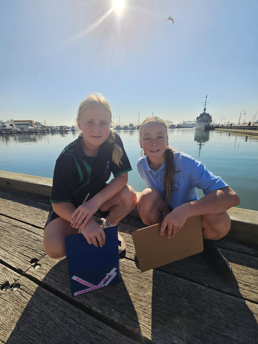
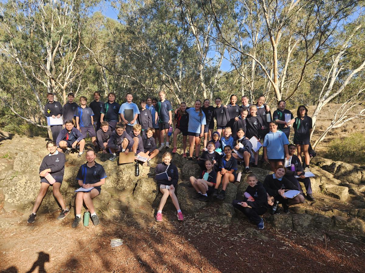
Geography Excursion By Evie Lockens
On the Tuesday 13th of May, the 5's and 6's went on an excursion to three places around Melbourne to examine the geographical features. We got on the bus at 9am ready to go to our first destination, Organ Pipes National Park. We then went to Newport Lakes before going to our final destination, Williamstown Wharf. Throughout the day, we had to answer questions about where we were and what the key geographical features were.
Organ Pipes: When we arrived at Organ Pipes we saw that the car park was made of scoria cone. We had to walk down a steep hill to get to the bottom in order to see the beautiful Organ Pipes. According to Organ Pipes National Park visitor guide, about a million years ago, molten lava flowed over the Keilor Plains from Mount Holden and other nearby volcanic hills. When it had cooled and solidified, it turned into basalt. Lava filled a river valley running at right angles to Jacksons Creek. Once a surfaced crust had formed, the lava beneath slowly cooled, contracting and surface cracks developed. As it continued to harden, the cracks lengthened until the basalt mass was divided in columns. Before we were going to climb back up the steep hill, we took a whole year 6 photo on the Tessellated Pavement. Tessellated Pavement consists of the tops of the basalt columns. We saw heaps of possum holes and many different types of birds. I really enjoyed looking at how high the basalt columns were and the surprising amount of cacti surrounding them. Although it felt like a hike climbing back up the hill, I had a great time.
Newport Lakes: Our second stop was Newport Lakes. Newport Lakes was transformed from a former bluestone quarry and rubbish tip. Spanning 33 hectares, the park has been revegetated with native flora and now has over 200 plant species and 165 bird species. The area was originally shaped by volcanic activity around 4.5 million years ago. It is placed on the traditional lands of the Yalukit-willam people of the Boon Wurrung (Bunurong) Country. With the disturbances a dog could create, it’s a no dog area. Newport Lakes was a really cool spot because it had these big stepping stones that go across the lake.
Williamstown Wharf: Our third and final destination was Williamstown Wharf. As soon as we arrived, we had to huddle in a big group and listen about the background history. We all had a look at the water when my friend Quinn, spotted a starfish. We kept seeing more and more sea creatures like a banjo shark/fiddler ray. Williamstown Wharf is situated on the northern shore of Port Phillip Bay, offering a calm swimming area due to the bay’s natural protection from large ocean swells. Williamstown has a rich Indigenous history. The area now known as Hobsons Bay was originally inhabited by the Yalukit-Willam clan of the Bunurong people, who were part of the broader Kulin Nation. As the first peoples of this region, they lived along the coastal strip from Werribee to Williamstown, maintaining a deep spiritual and cultural connection to the land and waters. Some sections behind the Wharf feature low dune systems with coastal grasses and shrubs, important for establishing the shoreline and supporting the bird life. As we were walking back to the bus I dropped my pencil and it fell into one of the cracks in the wharf. I got a new pencil and I dropped it again just after I finished writing. I got my third pencil but luckily I didn't need to get a fourth!
In conclusion, we had a great time looking at all of the geographical features. My highlight of the day was Williamstown Wharf because of the amount of creatures we saw. I would love to go back again sometime soon.
Building Consistency and Excellence in Writing at Holy Cross
At Holy Cross, one of the many ways our staff maintain a shared understanding of the curriculum, and ensure fair and accurate analysis of student learning, is through our whole-school practice of moderating student writing samples.
This term, all students across the school completed a writing task in response to the same prompt and for the same purpose - whether it was to entertain, inform, persuade, etc. This consistent approach allows us to collect comparable writing samples across year levels and use them to support rich professional discussion and reflection.
Why do we moderate?
Moderation is the process of teachers coming together to review and assess student work samples against the Victorian Curriculum Achievement Standards. It allows us to develop a shared understanding of what success looks like in writing at different stages of learning. By closely examining what students have produced, we ask:
- What is to be learned?
- How is learning progressing?
- What will be learned next?
What’s the value?
Moderation is more than just marking. It is a collaborative and professional learning process that:
- Strengthens teacher knowledge of the curriculum and student achievement
- Builds consistency in teacher judgments across year levels
- Identifies next steps in learning to guide future teaching
- Ensures equity for students, so all are assessed fairly against the same standards
- Celebrates the growth and strengths in students’ writing across the school
To support our assessments, we refer to annotated work samples provided by VCAA (Victorian Curriculum and Assessment Authority), and we cross-check across levels to ensure every sample is placed accurately.
This practice helps us to ensure that every student’s progress is accurately understood and that our teaching remains targeted, purposeful, and aligned with the standards.