Year 3/4 Bulletin

Positioning and Locating
Math Focus:
Positioning and Locating
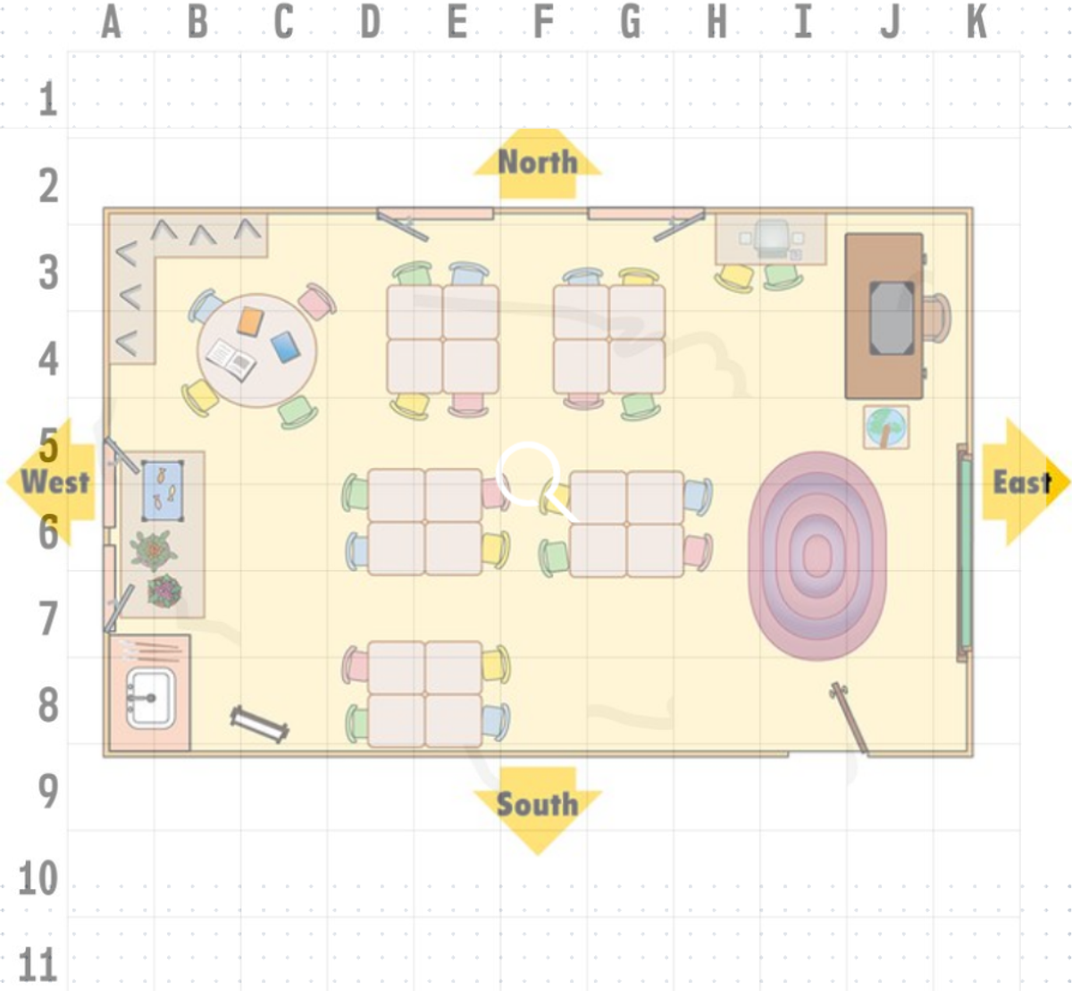
Work Sample: Map of Your Classroom
Learning Intention:
Students will create a bird’s eye view map of their classroom that includes grid coordinates and compass directions.
Description:
In this engaging activity, students developed their understanding of spatial awareness and mapping skills by creating a detailed bird’s eye view map of their classroom. Using grid coordinates, they identified and marked key locations within the classroom, such as desks, the teacher’s desk, and other important areas. They also incorporated compass directions (North, South, East, West) to enhance their navigational skills.
This hands-on task allowed students to apply mathematical concepts in a real-world context, fostering critical thinking to accurately represent their learning environment. By the end of the activity, students produced a comprehensive map that not only demonstrated their ability to position and locate objects but also served as a useful reference for understanding spatial relationships.
Fluency Game: BattleShips
Get ready for some fun with the classic game of BattleShips! Here’s how to play:
- Set Up: Each player secretly arranges their ships on the bottom half of their grid box.
- Take a Shot: Players take turns calling out a location on the grid (e.g., A-1, D-4) to target their opponent's ships.
- Response: After each shot, the opposing player announces “hit” or “miss” based on whether their ship was struck.
- Track Your Hits: Use red and white pegs to keep track of hits and misses on the top half of the box. The first player to sink all their opponent’s ships wins!
Task Overview:
Map Creation You’re tasked with designing a map of your classroom or an ideal classroom! Make sure to include enough desks for all your classmates.
- Enabling Level: Draw a simple bird’s eye view map of your classroom.
- Exploring Level: Enhance your map by adding grid coordinates for key features in the room.
- Extending Level: Further develop your map by incorporating compass directions along with grid coordinates.
Challenge: Write five questions for a friend to solve using your map.
For example: “Start at the teacher’s desk and describe the direction to the bookshelf.”
Student Work Samples:
Once completed, the maps will be sent home, with a short reflection, for students to share with their families, providing an opportunity for discussion about the concepts of positioning and locating in everyday life. This not only reinforced their learning but also engaged their families in the students’ mathematical journey.
Conclusion:
This engaging approach to positioning and locating, along with map-making, enhances students’ language skills while fostering spatial awareness and understanding of location through grids and compass orientation. This aligns beautifully with our curriculum objectives.
What You Can Do at Home:
Encourage exploration by asking your child to create a map of their favourite room at home. They can use grid coordinates and compass directions to enhance their understanding of mapping skills. It’s a fun way to reinforce what we’ve learned in class!
Happy mapping!
Allira, Richard and Roula
Year 3/4 Team
Allira.Zeneli@education.vic.gov.au